My Bottle Digger’s and Treasure Hunter’s Lament
It’s a conspiracy, I tell you.
From the age of 20 or so I’ve been a bottle digger, treasure hunter. (At least I find bottles.)
But it’s getting harder and harder all the time.
Right now, here on the lower mid-section of Vancouver Island, we’re in the grip of intense summer sunshine and heat. Meaning that the fire gates are down until an extended break in the weather which could well be two months away.
(Then, before you know it, the weather will change and we’ll be barred from the higher elevations by snow. It has ever been thus…)
The threat of forest fires and snow are seasonal things. But being locked out of backcounry is an increasing year-round threat to anyone wanting to hike, bike or ATV in the woods. (Those who abide by the signs, anyway.)
Recreationists aren’t wanted
I mean, there are hundreds of thousands of hectares of Crown land available for exploration, hunting, fishing and camping. Crown means public lands, owned by the province—us. But many of those acres of forests, lakes and rivers are now barred to public use.
As for the even more territory owned and/or leased by forest companies, the restrictions are even tighter. It’s getting to the point that recreationists can’t even leave the highway without running up against no trespassing or active logging signs.
Case in point:
One of my favoured areas for historical reconning is Copper Canyon. For years, there was a gatekeeper who permitted entry if you signed in; the only real restriction was on your time. You had to be back and out before he locked up. A friend got caught late and it cost him over $100 to phone a posted number in Chemainus for someone to come and free him.
Then they erected a second gate, several miles farther along the mainline which originally had been logging railway grade hence my interest in poking about. Also there beside the Chemains River, directly across from the Lenora Townsite on the west bank of Mount Sicker, was the site of the Mount Brenton copper mine.
This one dated back to the same turn-of-the-last-century period as the excitement on Mount Sicker and was initated in the hope that the fabulously rich copper strike across the river carried, underground, to what optimistically became known as Copper Canyon.
Ironically, despite some of the most glowing mining reports of that period which rated this property as being literally a gold (copper) mine, it never entered commercial production. But the property, and much of Copper Canyon, Mount Brenton and adjoining territory remain under lease to multinational mining companies and have been for decades now.
They must know something to have secured this sizable area for so long.
Copper Canyon is also the site of the famous Macmillan Bloedel Camp 10 logging camp and the truly massive Lidgerwood skidder that’s abandoned beside the main road. It really should be at the B.C. Forest Discovery Centre but the costs and logistics of moving it probably have scuttled any chances of that happening.
Which is a crying shame. It’s a marvel of engineering and loggers’ ingenuity. Originally steam-powered, it was converted to diesel, probably in the 1940s. Now it’s just a graffiti-d derelict in the bush…
Also in this area is the once well-known logging community of Rounds, site of the first signing of a labour contract with the International Woodworkers of America in the 1920s.
Rusted bedrames are a tell-tale sign of a camp.
Friends and I have enoyed some serious scratching at Rounds, which is rich in Easter lilies in the spring and cursed with Devil’s Club year-round. You can tell you’re on the site of an abandonded community by, if nothing else, the rusted and burned bedframes.
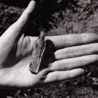
Jennifer’s most memorable find, as I recall, was in what probably were the remains of the machine shop. It’s a miner’s tag, my alltime favourite treasure, this one having been used to ‘sign out’ tools the same way a coal miner ‘signed in’ when he went to work by exchanging a tag bearing his official number for a lamp.
The tag is definitely the same as those used in the Dunsmuir mines in the Nanaimo, Extension, Wellington and Cumberland mines. It probably was bought secondhand, a common practice among the frugal and enterprising logging companies in the good old days.
I’ve dug up many a miner’s tag but always at coal mine sites; this is the only case of finding one in a former logging camp.
Then there’s the old powder magazine, just off the mainline, built of railway ties. In other words, built to last. And it has, even after some moron tried to set fire to it.
But so much for Copper Canyon which is now off-limits to recreationists.
In some cases members of the public can buy their way onto private logging lands by giving a deposit as a surety of good behaviour to the companies involved. This can be pricey; as much as $500 in some cases.
Some recreationists buy a (so-called) Free Miner’s License which is supposed to be a free pass to Crown lands for the purpose of prospecting. But I’ve heard cases of logging companies rejecting these, too.
(I should point out that, too many times in the past, forest companies have had good reason to regret public access to their timber leases. Thefts and vandalism have long been a threat to parked logging machinery, much of it extremely expensive.
That said, however, as late as the 1990s, some companies even encouraged the public’s enjoyment of their logging tenures by installing picnic tables and toilets and publishing maps showing access. Legitimate public access gave the companies extra sets of eyes to watch for criminal activity and fires.)
But no more.
Logging companies don’t actually own much of the land we want to explore.
And, remember, much of this land isn’t owned by the forest companies, they’ve simply leased it. But that’s enough to give them de facto control by throwing up an Active Logging sign and dropping a gate across the access roads, many of which are publicly gazetted and have in fact been used by the public for decades.
E.g.: the Mount Sicker Road from the Westholme side was built by the province a century ago to open the area to mining. Today it still runs through the fabled ghost town and the Municipality of North Cowichan’s commercial forest. Just try using it!
Well, you can, of course. Dirt bikers and ATVers don’t let piddly gates stop them from enjoying the great outdoors; they simply go around, usually making a bloody mess of the landscape and inviting ‘deactivation’ by North Cowichan which, in turn, makes another bloody mess of the landscape.
But those of us who drive regular 4x4s are, for the most part, SOL.
Three weeks ago, acting on a hot tip,
Jennifer and I returned to Cottonwood Creek, just beyond Youbou on the North Shore of Cowichan Lake. The road following the west side of the creek is the 1920s mainline of the Jesse James logging company.
We’d been there several times in the past and had some success in finding a previously undiscovered Chinese dig. Chinese bottles and pottery are among my favourite finds as the bottles are usually of very attractive teal blues and greens, greatly flawed from their crude manufacture, and the pottery is also very distinctive.
And both tell the story of our maligned Chinese pioneers who were originally imported to build the Canadian Pacific Railway in the 1880s then left to return to China, if they could afford to, or to fend for themselves.
Those who stayed became some of our most industrious province-builders and it never fails to please me when I find evidences of their activities. In this case, they’d built a bridge which took them just long enough to leave tracces of their meals on the job.
At least we tried.
Anyway, two Sunday hikes in a row proved fruitless and our hot tip proved worthless. But nothing ventured, nothing gained, eh?
A final complaint. Why is it that most bottles are brown (amber) and green? Why is it that most metal artifacts are rusty brown? Why is it that the foliage in our rain forest is mostly brown and green, making it extremely difficult to discern bush from bottles and artifacts?
It’s a conspiracy, I tell you!
Just a reminder that I tell the full story of the Mount Sicker copper strike in my book, Riches to Ruin.–TW
Hello, do you happen to have the coordinates of the Lidgerwood skidder as mentioned in this article? I am a summer student at the BC Forest Discovery Centre, and I would like to check it out.
Thanks,
Evan
I don’t but a friend may have. I’m waiting for him to get back to me and I’ll let you know.
Ok, thank you so much!
I’ve tried reaching him again, Evan. Waiting to hear back.